fbpx

November 20, 2023

Collaboration for Wildlife Connectivity Continues in Oregon’s Malheur River Canyon

In eastern Oregon, the Burns Paiute Tribe is leading an effort to make roads safer for drivers and deer

Most hunters in Oregon know the Malheur River and surrounding canyons offer great mule deer and chukar hunting. Most are also aware that US Highway 20 cuts right through the heart of prime deer winter range and has become a well-known hotspot for wildlife-vehicle collisions. Oregon Department of Transportation data shows that every year 3-5% of Oregon’s total recorded deer-vehicle collisions occur in the Malheur River Canyon as wildlife attempts to cross the highway to access seasonal and daily needs. The result is accidents that pose a major threat to human safety, ecosystem connectivity, and wildlife conservation. This level of mortality, particularly occurring in early winter and spring, has significant implications for the sustainability of deer populations that use the area for winter range and fawning grounds.

Thankfully, the Burns Paiute Tribe is leading a multi-year comprehensive effort with TRCP, local landowners, elected officials, and other partners to reduce the habitat fragmentation and deer mortality caused by Highway 20. Healthy populations of mule deer are important to the Tribe, which manages a Wildlife Mitigation Site that is bisected by the highway. In 2020, the Burns Paiute Tribe published a blog in collaboration with TRCP that detailed the problem the highway poses to mule deer and the ongoing research to study the movements of mule deer in the canyon and their patterns on and across the highway.

Since 2020, the Tribe and partners have had several successes to advance connectivity in the canyon and the coalition.

Figure 1-U.S. Highway 20 between Juntura (west) and Harper (east), Oregon. 

New Funding Means Good Work Ahead

The Oregon State Legislature, led by Representative Ken Helm (D, House District 27), passed bills allocating $7 million (2021) and $5 million (2023) for wildlife crossing projects in Oregon. A portion of these funds have been set aside for funding future wildlife crossings design and construction in the canyon.

In 2021, the Burns Paiute Tribe contracted a consulting firm to complete the “Highway 20 Wildlife Connectivity Feasibility Study” to better understand critical issues and the variety of challenges related to wildlife connectivity documented along this corridor. In June 2022, the Tribe hosted a community forum in Juntura, with support from Oregon Solutions, to gauge public perceptions about the issues and to determine if the local community members were interested and ready to collaborate. At a Wildlife Passage Summit in Burns in September 2022, presentations were shared with a broader range of stakeholders and relevant agencies about the current research, data, and information collected to date.

Additionally, in 2023, the Oregon Department of Fish and Wildlife, in cooperation with the Tribe, used Pittman-Robertson funds and commissioned another report by well-known wildlife crossing expert Dr. Marcel Huijser with the Western Transportation Institute. The report details potential future mitigation measures that would reduce collisions while maintaining permeability for wildlife.

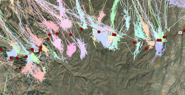
During the winter months, many deer cross the highway regularly. However, some mule deer will winter further south, and these animals may only cross US Hwy 20 twice per year, once during spring migration and once during fall migration. The location data from 10 individual mule deer were used in the report to calculate the diameter of the winter home ranges (Figure 2). Based on the diameter of the home range of mule deer that winter along both sides of the highway, a suitable crossing structure would be needed every 1.04 miles to allow 50% of the mule deer to access at least one suitable structure.

The report also indicates the design specifications for wildlife fences, crossing structures, wildlife jump-outs, measures at fence-ends and access roads, and a spatially explicit configuration of the mitigation measures. It also recommends that to achieve a substantial (>80%) reduction in collisions with mule deer, the entire road section should be fenced and additional designated wildlife crossing structures are needed.

Figure 2-Movements of individual GPS-collared mule deer along US Hwy 20 ( Credit Tom Segal, ODFW).

The combination of funds raised to date, research completed, and the level of community involvement in this effort is encouraging progress, and the TRCP is committed to continue our work with the Tribe and agency partners to see these crossing structures through to completion as soon as possible.

Moving forward, the Tribe, TRCP, and partners look forward to engaging in the 2024 stakeholder engagement process with Oregon Solutions. For over 20 years, Oregon Solutions has helped communities across the state implement hundreds of projects by facilitating an impartial forum that fosters public-private-civic partnerships to address community-based problems and projects that support economic, environmental, and local objectives.

Ultimately this process will develop functional solutions that improve wildlife and habitat connectivity through the development of safe wildlife crossings in the Malheur River Canyon. Those involved in the project are excited to have the support and expertise of the facilitators at Oregon Solutions to craft a locally driven solution to this fixable, and expensive, barrier to migration.

Learn more about the migration and conservation work being done in the Pacific Northwest here.

Photo credit: Nigel Hoult

One Response to “Collaboration for Wildlife Connectivity Continues in Oregon’s Malheur River Canyon”

  1. Kurt S Kremers

    There are many wildlife crossing needs in Oregon, it is great to see that Hwy 20 in this area will get some help for the Mule Deer and many other species. Theses type of projects should continue to be a priority for the safety of migration and the people who drive in these areas. Keep up the good work, there is so much more to be completed.

Do you have any thoughts on this post?

XHTML: You can use these tags: <a href="" title=""> <abbr title=""> <acronym title=""> <b> <blockquote cite=""> <cite> <code> <del datetime=""> <em> <i> <q cite=""> <s> <strike> <strong>

Comments must be under 1000 characters.

November 16, 2023

Why Hunters and Anglers Are Stepping Up for Alaska’s Brooks Range

What’s at stake and how you can urge the Bureau of Land Management to prevent the risky Ambler Road project

The Brooks Range of Alaska is the pinnacle of wild country. This largely unbroken chain of mountains buckle into foothills thick with willow and blueberry, as cold creeks fill wetlands and large rivers braid their way through the valleys.

Here, massive sheefish — otherwise known as “the tarpon of the north” — inhale streamers and jerk baits. Tundra swans glide over oxbows, 50-plus-inch Yukon moose wade in the marshes, Dall sheep survey from the shale slopes, and the largest caribou herd in Alaska migrates over the vast landscape to spend their winters in the south.

This is a dream destination for many hunters and anglers. Alaskans and visitors from across the globe revere this wild country for the world-class hunting and fishing it provides, as well as the adventure it promises. But a risky project could permanently alter the bucket-list experiences you can currently enjoy in the Brooks Range. Here are the details and how you can get involved.

Where Risks Outweigh Potential Rewards

In 2020, the U.S. Department of the Interior granted federal permits for a road to connect the Dalton Highway in north-central Alaska to four undeveloped mineral deposits. The proposed Ambler Industrial Road, a 211-mile corridor, would scrape itself across the southern foothills of the Brooks Range to bring foreign-owned mining companies within reach of what could become at least four open pit mines. The economic feasibility of these mineral deposits is still in question.

Due to the vast number of streams, rivers, and wetlands along the proposed corridor, the massive undertaking would require breaking up free-flowing waters with nearly 3,000 culverts and 29 bridges. Industrial vehicles would make an estimated 168 trips per day along the private corridor, diminishing the wilderness character of the area and the quality of hunting and fishing opportunities.

While our nation needs minerals to support our economy and way of life, the risks to habitat, clean water, and this wild landscape far outweigh any potential rewards from the Ambler Road project.

This is why the TRCP has partnered with Hunters and Anglers for the Brooks Range, a coalition of hunters, anglers, conservation organizations, hunt-fish businesses, and Alaskan guides, outfitters, and transporters to make sure our unique voice is heard on this issue. Time and time again throughout the conservation history of this country, the hunt-fish community has proven that we are stronger when we work together.

Now we undertake the challenge to conserve the most wild and remote hunting and fishing grounds in North America.

What You Can Do

The TRCP and Hunters and Anglers for the Brooks Range are urging the Bureau of Land Management to maintain the unique values of this iconic landscape by denying the right-of-way for the proposed Ambler Road. You can lend your support by taking action during a public comment period that ends on December 22, 2023.

Learn more about the hunting and fishing opportunities in the Brooks Range, get the facts on the proposed Ambler Road, and take action on the Hunters and Anglers for the Brooks Range webpage.

Fishery Managers Eye Changing 2024 Striped Bass Management Measures

After recent stock projections were worse than expected, the ASMFC Striped Bass Management Board is seeking angler input as it gauges the adjustments necessary to meet the rebuilding timeline for the striped bass stock.

The Atlantic States Marine Fisheries Commission is considering adjusting management measures for the recreational and commercial Atlantic striped bass fishery, in order to rebuild the stock to its biomass target by 2029. As part of the process, recreational anglers will continue to have a chance to let managers know they care about the future of striped bass. 

In May 2023, the ASMFC Atlantic Striped Bass Management Board initiated the development of a Draft Addendum II to Amendment 7 – a 2022 overhaul to the Atlantic striped bass management plan – after revised stock rebuilding projections showed that the chance of rebuilding the striper stock by 2029 has dropped from 97% to 15%, due to increased fishing mortality rates during the 2022 season. The draft addendum additionally proposes options for the Board to respond to stock assessment updates more quickly, if future projections indicate that the stock is not expected to be rebuilt by 2029. 

Unfortunately, catch reductions in recent years have proven insufficient to rebuild the striped bass stock, and the fishery remains in decline. The Board already took emergency action this season to implement a 31” maximum fish size restriction to protect spawning-size adults. Based on the revised stock projections, the potential management options laid out in the draft addendum are aimed to build upon that action.  

Current stock projections indicate that a 14.5% reduction in total striped bass removals in 2024 is necessary to prevent further decline. This reduction could be accomplished through a variety of management actions, including via different combinations of bag and size limit options for the ocean and Chesapeake Bay recreational fisheries, and various commercial quota reduction options. The TRCP and its partners have been collaborating and closely monitoring the situation to keep anglers informed on the various management options that remain on the table. Click here to read an informational document which details our partnership’s preferred options and gives additional context to each section of the draft addendum.

What Anglers Can Do

As the 2029 deadline to rebuild the coastwide stock approaches, it’s critical to remember that every one of us can do our part for striped bass. Throughout this process, it is imperative to let your voice be heard, to let managers know that you and the entire recreational community care about the future of striped bass – as well as menhaden and other forage fish species they depend on – and recognize that near-term sacrifice is necessary to ensure a robust striped bass fishery, for the coming years and our next generation.  

We strongly encourage recreational anglers to provide input on striped bass management by attending state public hearings, either in-person or virtually, or by providing emailed or written comments. The ASMFC Draft Addendum II to Amendment 7 document can be found here, and the public hearing schedule can be found here.  Each management action taken now, informed by angler input, lays the groundwork for the recovery of this important species. 

Just as important as making your voice heard are the actions you take on the water, to support the conservation of striped bass. Know the rules, and minimize your handling of fish – especially those above the slot limit – to get them back in the water as safely and quickly as possible.

What’s Next  

The next striped bass stock assessment is scheduled to be published in fall 2024, and will include fishing data through the 2023 season. This information will tell anglers and managers whether striped bass have been responding positively to past management actions, and whether any new measures are needed to reduce fishing mortality.

Click here for an informational document that details our partnership’s preferred management options

Photo Credit: Nils Rinaldi

November 15, 2023

Proposed State Land Auction Threatens Habitat & Hunting Opportunities Near Grand Teton National Park   

TRCP asks for a better solution to raise money for public education while conserving big game habitat

Nestled between Grand Teton National Park and the Bridger Teton National Forest lies a single section of state-owned land. Besides the incredible views and proximity to the National Park, the “Kelly Parcel” is a gateway to the scenic Gros Ventre River drainage and along the path migrating elk take to the National Elk Refuge. A mix of aspens, conifers, and sage intertwine with native grasses, providing habitat for numerous native species of wildlife.  

However, the future of this land is at risk. To meet its fiduciary duty to generate revenue for education, the Wyoming Office of State Lands and Investments has proposed to dispose of the Kelly Parcel via public auction, which could lead to development and permanent loss of invaluable habitat if it ends up in the wrong hands. 

The OSLI exists to manage state-owned land for the primary purpose of generating funds for the Wyoming public school system. To do so, state land is leased for uses like grazing, mineral extraction, or recreation.  Leases on the Kelly Parcel currently exist, but due to its appraised value at $62 million, disposing of the land would increase annual profits for the state through interest dividends.  

According to the Wyoming Game and Fish Department, the Kelly Parcel is valuable habitat for 87 “Species of Great Conservation Need” including moose, bald eagles, and bighorn sheep. In addition, it is a key piece in multiple species’ migration corridors including elk, deer, and the world-famous “Path of the Pronghorn.” During spring and fall migrations, more than 1,000 elk pass through the parcel at one time. 

The Kelly Parcel also provides valuable hunting opportunities for elk and bison, along with river access to the Gros Ventre River. This piece likely offers the most recreational opportunity out of all state land parcels in Teton County. Keeping this parcel accessible to the public and conserved for its irreplaceable habitat values should be at the forefront of anybody’s mind who enjoys wildlife, recreation, and the outdoors in Teton County. 

We understand the critical importance of raising funds for public education via state lands and believe the state can meet its fiduciary duty while also conserving the Kelly Parcel. The privatization and development of the parcel would benefit a few with extraordinary wealth at the detriment to Wyomingites who come to the area to visit, hunt, view wildlife, and experience this iconic landscape. Instead, we ask the Office of State Lands and Investments to work with a diverse coalition of Wyoming citizens to find a solution that benefits our school children while ensuring they have a future to experience the wildlife who depend on this parcel.

If you care about open spaces, wildlife, and the future of the Kelly Parcel, please consider attending one of three public hearings listed below, or submit written comments using our easy tool here. 

Thursday, November 16, 5:30pm

Thyra Thomson State Office Building

Round House Room

444 W. Collins Drive

Casper, WY 82601

Tuesday, November 21, 5:00pm

Laramie County Library, Cottonwood Room

1st floor

2200 Pioneer Avenue

Cheyenne, WY 82001

Tuesday, November 28, 5:30pm

Wyoming Game and Fish Department Cody Field Office

Cody Field Office Public Meeting Room

2 Tilden Trail

Cody, WY 82414

Photo credit: Josh Metten

November 14, 2023

West’s Senate Testimony Requests Long-Term Commitment for Big Game Migrations 

Appearing before the Senate Environment and Public Works Subcommittee on Fisheries, Water, and Wildlife, TRCP public lands director Madeleine West encouraged lawmakers to make strategic investments in migration research and conservation

Today, the Theodore Roosevelt Conservation Partnership was honored by the opportunity to participate in a hearing focused on wildlife corridor conservation held by the Senate Environment and Public Works Subcommittee on Fisheries, Water, and Wildlife.

For many years, TRCP has worked with elected officials and state, Tribal, and federal agencies to support partnerships, policies, and funding that advance the research and conservation of big game migration corridors and crucial seasonal habitats. West’s testimony focused on the long-time bipartisan support for this work and the need for dedicated funding to maintain and grow several existing Department of the Interior-led programs created in 2018 through Secretarial Order 3362: Improving Habitat Quality in Western Big-Game Winter Range and Migration Corridors.

“All across the Western U.S., big game herds make seasonal movements year after year from their summer ranges to their winter ranges and back again—passing down migratory knowledge from one generation to the next,” said Madeleine West, director of the center for public lands for the Theodore Roosevelt Conservation Partnership. “By making sure those seasonal habitats are connected by healthy, intact migration routes, we allow a multitude of species a greater ability to adapt and bolster their resilience to habitat changes now and into the future.”

West also highlighted how support for wildlife corridor conservation has persisted across three presidential administrations and continues to earn support from a bipartisan collection of governors in the West. She further articulated how this work was elevated in 2018 with the signing of Department of the Interior Secretarial Order 3362. Secretarial Order 3362 instituted a suite of programs and financial incentives to support local efforts to improve data collection, conduct research, and complete on-the-ground conservation projects. The Biden administration furthered this work and has expanded their efforts to more directly include Tribal governments and the U.S. Department of Agriculture, which now incentivizes big game corridor conservation on private lands.

Despite these successes, West cautioned that the discretionary nature of existing federal programs and funding sources creates uncertainty about the future of wildlife corridor conservation work, and she requested help from Congress.

“The federal programs established through SO 3362 have had an enormous impact in furthering the conservation and enhancement of big game migration corridors, but the discretionary nature of the programs and their funding raises concern for their longevity,” continued West. “With a dedicated and consistent approach, this bipartisan work could have greater predictability and durability and could benefit more wildlife species and additional state and Tribal jurisdictions.”

West specifically requested help from Congress to provide:

• Clear Congressional direction for federal agency programs that support the research, mapping, and conservation of wildlife corridors.

• Dedicated and consistent funding for research, mapping, and conservation programs.

• Increased coordination between federal, state, and Tribal agencies, as well as private landowners and hunting, fishing, and conservation organizations.

Learn more about TRCP’s work to conserve big game migration corridors here.

Watch West’s testimony below.

HOW YOU CAN HELP

CHEERS TO CONSERVATION

Theodore Roosevelt’s experiences hunting and fishing certainly fueled his passion for conservation, but it seems that a passion for coffee may have powered his mornings. In fact, Roosevelt’s son once said that his father’s coffee cup was “more in the nature of a bathtub.” TRCP has partnered with Afuera Coffee Co. to bring together his two loves: a strong morning brew and a dedication to conservation. With your purchase, you’ll not only enjoy waking up to the rich aroma of this bolder roast—you’ll be supporting the important work of preserving hunting and fishing opportunities for all.

Learn More
Subscribe

You have Successfully Subscribed!

You have Successfully Subscribed!

You have Successfully Subscribed!

You have Successfully Subscribed!

You have Successfully Subscribed!